
Photos by Samantha Demangate
Sedona was magical. Any other description wouldn’t suffice. If I said anything more, it would be just another overused cliche, just like magical. Our last morning in Sedona was magical. The magical sunrise enveloped the magical rocks and canyons in magical colors impossible to capture with mind or camera. We drank our coffee and watched it intently. Minutes went by as we took it all in one last time before departing. Realizing that neither words or photos would do it justice, we stayed silent and mesmerized as we drove off.
Highway 89a parallels Oak Creek, snaking its way north from Sedona into Oak Creek Canyon. Campgrounds, hiking trails, and fishing spots are abundant in this stretch of the road. The ice cold pools of water at swimming areas like Grasshopper Point and Slide Rock provide relief from the summer heat. In winter their calm waters look like mirrors in the snow. Beautiful pine and oak forest surrounds the canyon as it makes its way higher in elevation inside the Coconino National Forest. At the Sterling Spring Fish Hatchery the highway begins its dramatic switchbacks up into the Colorado Plateau, following the changing strata of red and white sandstone. As you reach the end of the dramatic elevation gain you’re at the edge of the mighty Colorado Plateau. Rimmed by black basalt and towering ponderosa pine, this part of the landscape feels like you’ve crossed into the great rocky mountains.

The 6900 foot (2100 meter) elevation can hit you like a ton of bricks. And as the narrow highway 89a meets the Arizona Veterans Highway (Highway 17) at Flagstaff Pulliam Airport, the urban area of Flagstaff begins. The surrounding region is home to a number of early Native American Puebloan ruins including the spectacular Walnut Canyon National Monument and Wupatki National Monument, with its beautiful red sandstone structures and views of the snow-capped dormant volcano Humphreys Peak, Arizona’s tallest mountain.
Traveling north on Highway 89, there are several trading posts along the barren highway, the majority of them closed due to the pandemic, aside from the gas station across from the Gray Mountain Trading Post. Life out here, with all its challenges, would be full of quiet reprieve and still nights, we collectively thought. For city dwellers just passing through, it’s easy to conjure up our own romanticised projections of what life must be like out here in the high desert. Then the dream gives way to the current reality that is affecting the Navajo Nation in unimaginably cruel ways. The once thriving stream of tourists had dried up to a trickle. Trading posts are now mostly closed, lying abandoned along the highway, and worse of all, infection rates amongst the community have skyrocketed. A sobering reminder of the pandemic’s toll on marginalized communities that consistently jolted us from our day dream.

Passing the small town of Tuba City, in Navajo Nation, we entered Highway 160, also known as the Navajo Trail. In normal years Tuba City’s Navajo Code Talkers Museum is a great place to check out along with the preserved dinosaur tracks of the Moenave Formation. Continuing past Tuba City on the Navajo Highway we sat enwrapped in our space podcast and the endless contours of the red desert stretching into the horizon. At 1500 feet lower in elevation than Flagstaff, the layers of red sandstone once again become an omnipresent feature of the terrain. Within thirty miles the quintessential geologic monuments of the four corners area start to make their appearance. The first one we noticed were the Elephants Feet, two large conical buttes standing at attention by the highway. This region is extremely arid. Few plants survive the mars-like landscape until you get to the Cow Springs Oasis, a small pond oasis that sticks out amongst the red rock landscape like an emerald in the sand.

At our last major junction, we entered highway 163 in the town of Kayenta, a popular spot for food and lodging on the Four Corners route. From here we drove north, past ancient Puebloan cliff dwellings. The Pueblo Civilization — also known as the Anasazi, although this term is controversial — once thrived here as early as 1500 BC, until around the 13th century. They left countless structures built within the cliffs and hills throughout the region. What caused their civilization’s collapse remains a mystery.

The landscape started to feel monotonous after the novelty of being in it wore off. That is until we approached Utah and Monument Valley hit us like a ton of bricks. The sheer scale of the towering buttes was hard to fathom as we drove through these monoliths. Popularized in movies, TV shows, and magazines, these are some of the most iconic landmarks in the nation. Unimaginably empty of the usual tourist traffic, the landscape enveloped our imaginations as we stood outside the car for an hour absorbed in its scale and beauty. A large red-tailed hawk circled above us, adding to the surrealness of the scenery imprinting itself in our minds.

Just outside Monument Valley we stopped at one of the few open trading posts along the highway. There, we got to meet a young Navajo man patiently selling jewelry. He was eager to point out the location of his house just down in the valley, a mere stone throw from one of the famous buttes. We talked about how he returned home from the city to help his family. Hearing his account of the toll the pandemic has taken on his family’s economic and physical health was sobering. We happily bought a necklace made out of juniper berries, an item symbolic of safe travels; something we felt we needed on our journey, and wished him the best.

Our last stretch of highway took us into Utah, past the town of Mexican Hat bordering the San Juan River, and into the vast expanse of the Valley of the Gods. From here, we decided to hike around two significant Puebloan landmarks: The Wolfman Panel and the Sand Island Petroglyph Panel. First we veered onto the dirt road paralleling the Butler Wash. Climbing down into the ravine we got to the Wolfman Panel, named after a long scraggly human-like figure etched into the cave wall. The petroglyphs were painted by early Puebloan Indians and depict several figures, some unearthly in their appearance.
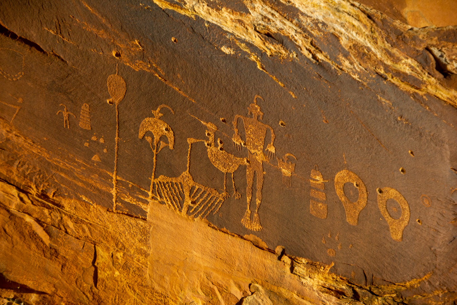

After exploring the cave area we hiked back to the car and drove the short two miles or so to the Sand Island Petroglyph Panel. A more easily accessed and famous set of petroglyphs, it spans several dozen meters of cliff face. Some of the art is possibly thousands of years old. The panel depicts animals playing instruments, large human-like figures, and morphed animal-like beings with headdresses. Their symbolism invoked in us imaginative explanations to how the early people of this region survived the harsh environment.
Our final destination on this epic day was the quiet town of Bluff, Utah. Its history dates back to the Puebloan Indians, with remnants of a Pueblo settlement known as The Great House nestled on top of a hill in town. The Morman’s were the first white settlers, and bravely (or foolishly) made the perilous journey by wagon through what is now known as the Hole in The Rock Trail. They built the now rebuilt Bluff Fort along with various homesteads in the area. During the end of the 19th century, the town attracted gold miners from across the country who heard about the possibility of discovering heaps of the precious metal in the San Juan River. Although the gold never panned out to be as plentiful as promised, many people stayed in the town to carve out a life for themselves in the beautiful high desert countryside.

We ended the night nestled outside in the 10 degree cold. Endless stars covered the sky above. WIthout the light pollution we’re used to, we watched the infinite celestial clusters, only the steam from our breath to obscure them. Our tiny cabin was the perfect place to rest after a long day driving through some of the most scenic and iconic landscapes in America.

Waking up we stepped outside only to be confronted by 10° F temperatures and an almost maroon colored sunrise. We packed up, warmed the car for ten minutes, and hit the road. Our next stop was the Four Corners Monument, currently closed due to the pandemic. The monument is one of the most visited sections of highway in the American West, yet like everywhere else, eerily empty. Here, the borders of four states: New Mexico, Arizona, Utah, and Colorado converge, allowing visitors a chance to jump from one to another. I particularly wanted to jump into Utah holding an out-of-state IPA, next time I guess.


Just a few miles south we hit Highway 64 and headed west into the town of Shiprock, named for the massive towering butte looming in the distance like the southwest’s Mordor. We continued northwest to our next destination, the Aztec Ruins. Located in the small town of Aztec, the abandoned Puebloan city is full of preserved stone buildings. These multistory buildings and their 400 or so homes were interconnected by narrow hallways and courtyards. In the center, a large domed ceremonial building known as the great kiva stands, open for visitors to explore. For us, this wonderfully preserved ancient town was an incredible side trip on our way to Santa Fe.
Beautifully written. I feel a bit like Im there with your descriptions. I particularly like the line, “the gold never panned out”.
Thanks Jennifer!!